Water column profiles were conducted at seven locations in the Providence and Seekonk River estuaries on September 6, 2023 using a Seabird Electronics profiler. In the five days leading up to the survey, no precipitation was recorded at T.F. Green. Most sites were moderately to weakly stratified this week.
Dissolved oxygen (DO) conditions were below the hypoxia threshold (2.9 mg/L) in the lower portion of the water column at the Pomham Rocks, India Point Park, and Phillipsdale Landing sites. The highest fluorescence readings for the week were measured around 1.5 meters below the surface at Edgewood Yacht Club.
Water column profile data was collected at a single site on August 31, 2023. Further collection was discontinued due to extreme weather conditions. In the five days leading up to the survey, 0.14 inches of precipitation were recorded at T.F. Green.
Data was collected at the Edgewood Yacht Club. The water column here was weakly stratified. Dissolved oxygen (DO) conditions were below the hypoxia threshold (2.9 mg/L) only at the very bottom of the water column. Fluorescence readings at this site reached a maximum value approximately 3 meters below the surface.
Water column profiles were conducted at eight locations in the Providence and Seekonk River estuaries on August 23, 2023 using a Seabird Electronics profiler. In the five days leading up to the survey, 2.16 inches of precipitation were recorded at T.F. Green. Most sites were moderately to strongly stratified this week, with the exception of Edgewood Shoals, which was weakly stratified
Dissolved oxygen (DO) conditions were below the hypoxia threshold (2.9 mg/L) throughout the water column (upper, middle and lower portions) at the Edgewood Shoals, India Point Park, and Phillipsdale Landing sites, but only in the middle and lower portions of the water column at Edgewood Yacht Club and Pomham Rocks. No hypoxic conditions were observed at Conimicut Point, Pawtuxet Cove or Bullock Reach Buoy. The highest fluorescence readings for the week were measured around 1 meter below the surface at Pawtuxet Cove.
Water column profiles were conducted at five locations in the Providence and Seekonk River estuaries on August 16, 2023 using a Seabird Electronics profiler. In the five days leading up to the survey, 0.59 inches of precipitation were recorded at T.F. Green. Most sites were moderately to strongly stratified this week.
Dissolved oxygen (DO) conditions were below the hypoxia threshold (2.9 mg/L) throughout the water column (upper, middle and lower portions) at the Point Street Bridge, India Point Park, and Phillipsdale Landing sites, but only in the middle and lower portions of the water column at Bullock Reach Buoy and Conimicut Point. The highest fluorescence readings for the week were measured around 1.5 meters below the surface at Conimicut Point.
Water column profiles were conducted at seven locations in the Providence and Seekonk River estuaries on August 9, 2023 using a Seabird Electronics profiler. In the five days leading up to the survey, 0.48 inches of precipitation were recorded at T.F. Green. Most sites were moderately to strongly stratified this week, other than Edgewood Yacht Club, which was weakly stratified.
Dissolved oxygen (DO) conditions were below the hypoxia threshold (2.9 mg/L) in the lower portions of the water column at Pomham Rocks and India Point Park, and in the middle and bottom portions of the water column at Phillipsdale Landing. The highest fluorescence readings for the week were measured around 2 meters below the surface at India Point Park.
Water column profiles were conducted at six locations in the Providence and Seekonk River estuaries on August 2, 2023 using a Seabird Electronics profiler. In the five days leading up to the survey, 0.66 inches of precipitation were recorded at T.F. Green. All sites were moderately to strongly stratified this week.
Dissolved oxygen (DO) conditions were below the hypoxia threshold (2.9 mg/L) in the middle and lower portions of the water column at every profiled site, and in the full column (upper, middle and bottom portions) at Point Street Bridge, India Point Park, and Phillipsdale Landing. The highest fluorescence readings for the week were measured around 2 meters below the surface at Conimicut Point.
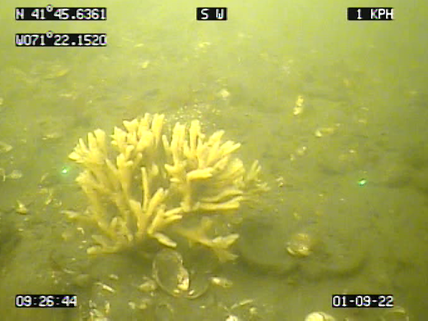
The boat crew conducted benthic video surveys along the Bullock Reach, Edgewood, and Sabin transects on September 1, 2022. Scale lasers were used in the footage, separated by 29 cm. Visibility through the water column was poor this week at all transects making fine observations difficult. The bottom of all sites was characterized by sands and muds. Sabin hosted dense patches of shell hash and rubble, as well as occasional boulders and cobbles. Bullock Reach and Edgewood both had sporadic patches of shell hash and rubble (more so at Edgewood). Algal coverage was limited this week. Sabin featured large mats of branching red algae (dominant, Ulva, and red sheet-like algae. General biotic activity was high at all sites as noted by extensive tracks and trails. Rare benthic video sights included many small schools of juvenile black sea bass (all sites), mantis shrimp Squilla (Bullock Reach and Edgewood), and flat fish (Edgewood). Infaunal activity was moderate; large burrows, likely from Squilla, and many small burrows were present. Common observations were spider crabs (Bullock Reach), boring sponges (all sites), hermit crabs (Sabin), and large colonies of mermaid’s glove sponges (photo below) and red bearded sponges (Sabin). Amphipod tube mats were not observed.
Please note: this blog publication has been post-dated to retain chronological order as a backlog of video footage is reviewed.
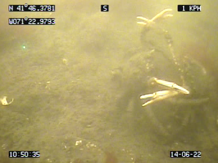
The boat crew conducted a benthic video survey along Bullock Reach, Edgewood, and Sabin transects on June 14, 2022. Scale lasers were used in the footage, separated by 29 cm. Visibility through the water column varied at each site from poor to fair. The bottom of all sites was characterized by sands and muds, with a few boulders and cobbles. Dense patches of shell hash and rubble were also observed frequently at Bullock Reach and Sabin. Algal coverage was diverse this week. Sabin experienced particularly dense coverage by Ulva, red sheet-like algae, and branching algae. Bullock Reach was dominated by sparse filamentous algae, while Edgewood was also dominated by Ulva and branching species. Infaunal activity was moderate (higher activity at Edgewood); large burrows, likely from mantis shrimp (Squilla), and some small burrows were present. Assemblages of small tube-building fauna were also common at all sites but more frequent at Edgewood. General biotic activity was moderate as noted by frequent tracks and trails (especially at Edgewood and Bullock Reach). Rare benthic video sights included horseshoe crabs spotted at Sabin and Edgewood, as well as moon snail eggs at Sabin, and a winter flounder at Bullock Reach. Common observations consisted of Nassariid mudsnails (Bullock Reach), slipper snail Crepidula (all sites), spider crabs (all sites, photo below), hermit crabs (all sites), boring sponges (all sites), channeled whelk (Bullock Reach and Sabin), soft-shell clam mya (Bullock Reach and Edgewood), blue crab (Edgewood), and egg masses produced by the lugworm Arenicola (all sites). Edgewood had what appeared to be amphipod tubes, though not at mat-like densities.
Please note: this blog publication has been post-dated to retain chronological order as a backlog of video footage is reviewed.
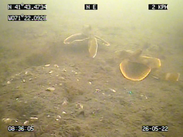
The boat crew conducted benthic video surveys along the Bullock Reach and Edgewood transects on May 26th. Scale lasers were used in the footage, separated by 29 cm. Visibility through the water column ranged from poor to good.
Both transects were characterized by extensive mud flats, with Bullock Reach also having sparse to dense shell rubble and sporadic boulders. Algal coverage ranged from sparse to dense, Edgewood being categorized by filamentous algae, and Bullock dominated by rafting Ulva; sparse to dense areas of diatom felt were also present. Edgewood’s central observations were large assemblages of egg masses produced by the lugworm Arenicola. Bullock Reach exhibited high biodiversity, featuring rare observations of striped bass, sea robins (photo below), small fish, Arenicola egg masses, and a horseshoe crab. Both transects demonstrated high infaunal activity; large, freshly excavated burrows (most likely mantis shrimp, Squilla) as well as smaller burrows, tubes, and fecal mounds were frequent sights. Additionally, both sites housed sponges, whelks, and boring sponges. Amphipod tube mats were not observed.
Please note: this blog publication has been post-dated to retain chronological order as a backlog of video footage is reviewed.
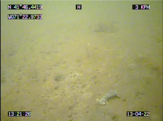
The boat crew conducted a benthic video survey along the Edgewood transect on April 13th. Scale lasers were used in the footage, separated by 29 cm. Visibility through the water column was poor. The bottom was characterized by sands and muds, with a few boulders and cobbles observed sporadically. Algal coverage ranged from sparse to dense, composed of Ulva as well as other filamentous and branching algae; sparse to dense areas of diatom felt were also present. Rare benthic video sights included a whelk trap, mantis shrimp Squilla (photo below), a horseshoe crab, and two moon jellies swimming among a swarm of ctenophores. Infaunal activity was high; large burrows, likely from Squilla, and many small burrows and associated fecal mounds were present. Common observations include channeled whelks, parchment tubes, Nassariid mudsnails, hermit crabs, sponges, boring sponges, small fish, and shrimp. Amphipod tube mats were not observed.
Please note: this blog publication has been post-dated to retain chronological order as a backlog of video footage is reviewed.